January 24 GFS Model Shows Massive Central U.S. Storm — But Meteorologists Say It’s a “Fantasy Run” With No Forecast Value Yet
UNITED STATES — A striking long-range weather model run showing a powerful storm system around January 24 has drawn attention online, but meteorologists are urging caution, emphasizing that the setup is not a legitimate forecast at this stage.
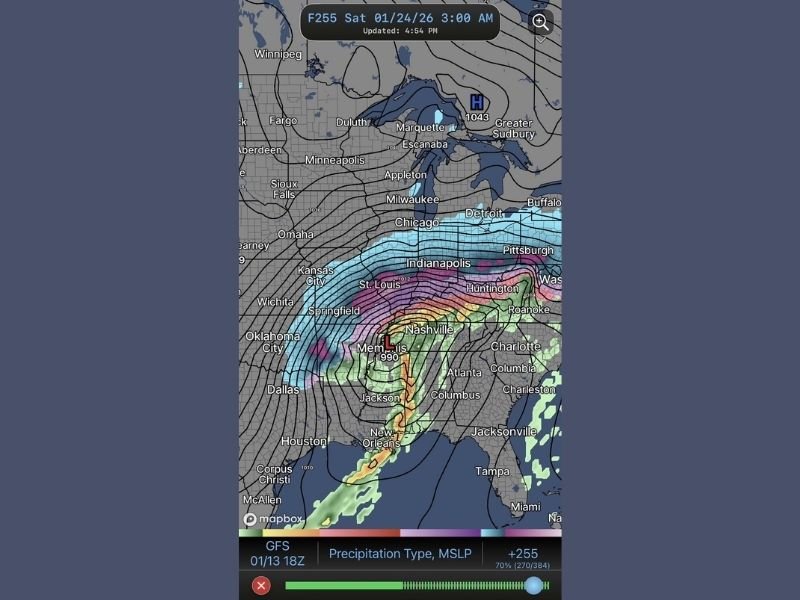
The image comes from the evening run of the GFS (Global Forecast System), which occasionally produces dramatic-looking storms far into the future. Forecasters say this particular run falls squarely into what professionals call a “fantasy system” — visually impressive, but scientifically unreliable.
Why This Storm Is Not a Real Forecast
Weather experts stress that single long-range model runs cannot be trusted on their own, especially when they appear more than a week into the future. At that distance, the atmosphere has too many variables for any one model snapshot to be meaningful.
Forecasters explain that a real forecast only begins to take shape when:
- Multiple models show a similar evolution
- The signal remains consistent across several days
- Shorter-range guidance starts to support the idea
None of those conditions are currently met for the January 24 system.
What the GFS Image Actually Shows
The model depiction features a deep low-pressure system tracking across the central United States, with heavy precipitation, strong winds, and sharp temperature contrasts stretching from the Gulf Coast into the Midwest and Great Lakes.
However, meteorologists say this type of output is common in extended-range GFS runs and often disappears entirely in later updates.
Why “Pretty Maps” Can Be Misleading
Experienced forecasters caution that eye-catching weather maps can easily be misinterpreted by the public. Without context, they may suggest certainty that simply does not exist.
Professionals note that fantasy runs frequently exaggerate storm strength, size, and impacts, especially when the atmosphere has not yet settled into a stable pattern that supports such a system.
When Confidence Would Increase
If a legitimate storm threat were developing, forecasters would expect to see:
- Agreement between the GFS, European, and Canadian models
- Repetition of similar storm tracks over multiple days
- Support from ensemble guidance, not just a single deterministic run
Until then, the January 24 scenario remains purely hypothetical.
Bottom Line
Despite the dramatic appearance of the January 24 GFS model run, there is currently no credible forecast for a major storm tied to this image. Meteorologists emphasize patience, reminding the public that reliable forecasts are built over time — not from a single long-range model snapshot.
Do you find long-range weather models confusing or fascinating? Share your thoughts and stay informed with ongoing weather coverage at SaludaStandard-Sentinel.com.