Pennsylvania Faces Dangerous Flash Freeze Wednesday Night as Temperatures Plunge Into the Teens and 20s by Thursday Morning
PENNSYLVANIA — A dangerous flash freeze setup is taking shape across much of Pennsylvania Wednesday night, as rapidly falling temperatures combine with wet roads and accumulating snow, increasing the risk for black ice, slick travel, and Thursday morning delays.
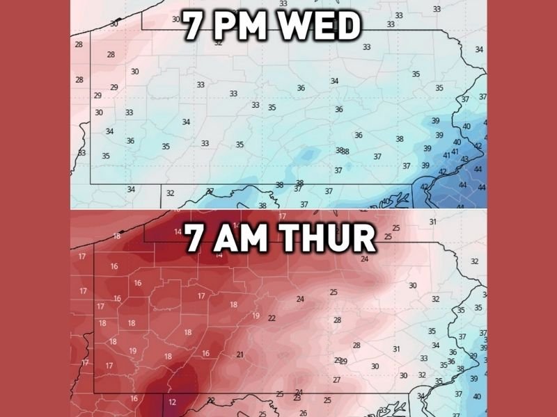
Forecasters say the concern goes beyond snowfall totals. With rain and melting snow lingering on road surfaces Wednesday evening, temperatures are expected to fall sharply overnight, causing anything that remains wet to freeze quickly.
Why a Flash Freeze Is Likely
Meteorological data shows temperatures dropping 2 to 3 degrees per hour at times late Wednesday night as a strong cold air surge moves in. By daybreak Thursday, much of Pennsylvania will see air temperatures in the teens to low 20s, with the exception of far eastern sections of the state, which may remain slightly milder.
This rapid cooling is a classic flash-freeze scenario:
- Wet pavement from rain and melting snow
- Snow continuing to accumulate in parts of the state
- Temperatures plunging well below freezing overnight
When these factors combine, ice can form faster than road crews are able to treat surfaces, especially on bridges, ramps, and untreated secondary roads.
Areas at Greatest Risk
The highest concern is focused across western and northern Pennsylvania, where accumulating snow is already expected and colder air will arrive sooner. In these regions, even small amounts of moisture can freeze solid in minutes.
Travel conditions could deteriorate quickly late Wednesday night and remain hazardous into the Thursday morning commute.
Impacts on Travel and Schools
Transportation officials warn that Thursday morning travel could be especially treacherous, with icy roads developing even where snowfall totals are modest. Drivers are urged to slow down, allow extra stopping distance, and watch for sudden icy patches.
School districts across affected areas may consider two-hour delays or schedule adjustments Thursday morning due to overnight snow and ice formation.
What to Watch Overnight
Forecasters advise residents to closely monitor updates through Wednesday evening and overnight. Conditions can change quickly as temperatures fall, and road conditions may worsen even after precipitation ends.
Anyone planning to travel early Thursday should be prepared for winter driving conditions and allow extra time. Have you experienced flash freeze conditions in your area before? Share your experience and stay informed with ongoing updates at SaludaStandard-Sentinel.com.