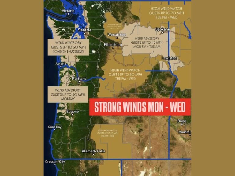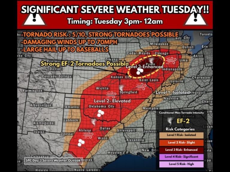
U.S. Climate Outlook Shows Neutral ENSO Through Spring With Growing Signals El Niño Could Redevelop by Summer and Intensify Wetter Conditions by Fall
UNITED STATES — Long-range climate indicators are increasingly pointing toward a neutral ENSO (El Niño–Southern Oscillation) pattern through the spring months, with a growing likelihood that El Niño redevelops later this year, potentially reshaping weather patterns across large parts of the country by late summer and fall.
Spring Likely to Remain Neutral
Climate guidance suggests that spring will largely remain under neutral ENSO conditions, meaning neither El Niño nor La Niña will dominate atmospheric behavior. During neutral phases, weather patterns tend to be less extreme overall, with fewer large-scale disruptions tied directly to Pacific Ocean temperature anomalies. Forecasters say this points to no immediate, dramatic shifts in national weather patterns during the early part of the warm season.
Summer Could Mark a Transition Phase
As the calendar moves into summer, signals indicate a transition period from neutral conditions toward El Niño. While this does not guarantee immediate impacts, it suggests that Pacific Ocean temperatures and atmospheric circulation may begin aligning toward an El Niño setup. During this phase, weather impacts often remain subtle and uneven, with meaningful changes typically lagging behind the initial oceanic signals.
Fall Brings Increasing El Niño Odds
The strongest signal currently appears later in the year. Climate models show increasing odds that El Niño fully re-establishes by fall, a development that historically leads to a more active Pacific jet stream.
If El Niño does take hold, forecasters expect wetter-than-average conditions across parts of the southern and central United States, though impacts can vary by region and often intensify as the season progresses.
What El Niño Usually Means for the U.S.
Historically, El Niño patterns are associated with:
- An energized Pacific storm track
- Higher precipitation potential across portions of the southern and central U.S.
- Delayed but stronger impacts later in the year, rather than immediate changes
Meteorologists stress that El Niño’s most notable effects often emerge months after initial development, making early signals important for long-term planning rather than short-term forecasting.
Bottom Line: No Immediate Change, But a Wetter Trend Emerging
While no major weather shifts are expected in the near term, the overall trend suggests the U.S. could be heading toward a wetter pattern later in the year, particularly if El Niño becomes established by fall.
Climate experts say this is a pattern they will continue monitoring closely over the coming months, as confidence typically increases with time and additional data. Do you think El Niño’s return could bring relief from drought or create new challenges later this year? Share your thoughts and questions with readers at SaludaStandard-Sentinel.com.