New England Winter Forecast Shows Minor Midweek Snow Followed by Uncertain Nor’easter Threat With Rain South and Heavier Snow Far North
NEW ENGLAND — Forecasters are tracking a weak, fast-moving snow system late Tuesday night into early Wednesday, followed by growing attention on two possible coastal storm systems later in the week that could bring rain, snow, or a mix depending on location — though major impacts remain far from certain.
Quick-Hitting Snow Possible Late Tuesday Night
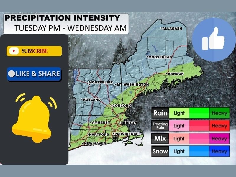
The first system expected to impact the region is a minor disturbance arriving between roughly 10 p.m. Tuesday and midnight, moving swiftly from west to east. While snowfall amounts are expected to be light, some residents may wake up to a fresh coating of snow Wednesday morning, particularly in inland and northern areas.
Meteorologists describe this system as short-lived and low-impact, with precipitation ending nearly as quickly as it begins. Travel disruptions should be minimal, though untreated roads could briefly become slick overnight.
Why This System Stays Limited
Despite cold air being present, the midweek system lacks deep moisture and strong storm dynamics. As a result, snowfall intensity and accumulation remain modest, making it more of a nuisance event than a significant winter storm. Forecasters emphasize that this type of fast-moving clipper is common in mid-winter patterns and typically does not produce widespread disruptions.
Attention Turns to Potential Coastal Storms
Beyond Wednesday, attention shifts to two areas of low pressure developing offshore, which have fueled widespread speculation about back-to-back nor’easters. While these features are clearly visible on forecast models, critical details remain unresolved.
What is currently confirmed includes the presence of cold air to the north, warmer air pushing in from the south, and the potential for both rain and snow across the region. However, key questions remain unanswered.
What Remains Uncertain
Meteorologists stress that snowfall amounts, rain totals, exact precipitation placement, and wind strength are still unclear. Small shifts in storm track could mean the difference between rain along the coast, mixed precipitation inland, or heavier snow confined to far northern areas.
Some forecasts suggest rain extending as far north as the White Mountains and central Maine, with 8 to 10 inches of snow possible north of that zone if colder air holds.
Perspective as Forecasts Evolve
Forecasters caution against overreaction, noting that similar winter setups occur nearly every year and often generate outsized expectations well before confidence increases. Until storm tracks and timing become clearer, major conclusions remain premature.
Residents are encouraged to monitor updated forecasts later this week, particularly if travel plans extend into the upcoming weekend. Are you seeing snow or rain where you live? Share your local conditions and thoughts on the evolving forecast with readers at SaludaStandard-Sentinel.com.