Arkansas, Missouri, Louisiana, and Tennessee Placed Under Low-End Tornado Risk as Strong Wind Shear Develops Thursday
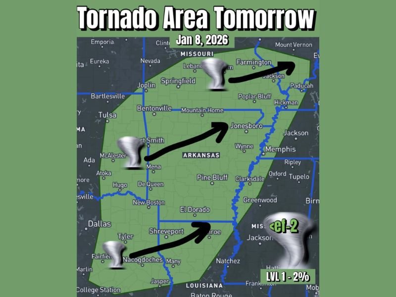
ARKANSAS — A broad stretch of the central and lower Mississippi Valley is facing a low-end but notable tornado risk on Thursday, January 8, 2026, as meteorologists track a large storm system centered over Arkansas and extending into surrounding states including Missouri, Mississippi, Louisiana, and western Tennessee.
Forecasters emphasize that while the overall tornado probability remains low, atmospheric conditions are becoming increasingly supportive of storm rotation, meaning one or two storms could briefly produce a tornado, especially later in the day and into the evening hours.
Level 1 Tornado Risk Covers a Wide Multi-State Area
The Storm Prediction outlook places much of Arkansas under a Level 1 (Marginal) tornado risk, with the risk zone expanding outward into neighboring portions of:
- Southern Missouri
- Northern Louisiana
- Western Mississippi
- Western Tennessee
A Level 1 risk does not indicate widespread severe weather. Instead, it highlights that most storms will remain below severe limits, but the environment contains just enough instability and wind shear for a small number of storms to briefly intensify.
Wind Shear Is the Primary Concern
Meteorologists point to impressive and unusually strong wind shear for January as the key factor driving concern. Wind shear refers to rapid changes in wind speed and direction with height in the atmosphere, which can allow storms to rotate.
Although instability levels are expected to remain limited, storm coverage is forecast to be relatively high. This means many storms could form, even if only one or two manage to briefly organize into something stronger. Forecasters stress that brief, short-lived tornadoes are the primary threat, rather than long-track or violent tornadoes.
Arkansas Remains the Core Risk Zone
Arkansas sits at the center of the risk area, with cities such as Fort Smith, Mountain Home, Jonesboro, Pine Bluff, and El Dorado falling within the highlighted zone. Storm motion is expected to move generally from southwest to northeast, spreading activity into Missouri and toward the Mississippi River by later in the day.
While most communities will likely experience nothing more than rain and gusty winds, the setup is sufficient for isolated severe hail and damaging wind gusts, in addition to the low tornado potential.
Timing and Overnight Awareness Are Important
Storms are expected to develop through the day, with the higher concern emerging later Thursday and into the evening hours as wind dynamics strengthen. While the severe risk remains isolated, forecasters caution residents not to dismiss the threat entirely, especially given the possibility of storms occurring after dark. Even weak tornadoes can be dangerous when visibility is limited, making weather alerts and warnings especially important overnight.
What Residents Should Know Right Now
This setup does not guarantee tornadoes, nor does it suggest widespread severe weather. However, it does signal an environment where brief, isolated tornadoes are possible, particularly across Arkansas and nearby states.
Residents across the risk area are encouraged to:
- Stay weather-aware throughout the day
- Keep mobile alerts enabled
- Monitor local forecasts for updates
SaludaStandard-Sentinel.com will continue tracking this developing weather system and provide updates as conditions evolve and confidence increases.