Colder January Pattern Emerges Across Minnesota, Wisconsin, Michigan, Illinois, Indiana, Ohio, Iowa, Missouri, Kansas, and Nebraska as Early-Month Warmth Breaks Down
UNITED STATES — After an unusually warm start to January, a notable pattern shift is underway across the Central Plains, Midwest, and Great Lakes, where colder air is beginning to replace the record warmth seen earlier this month. Forecast maps show below-average temperatures expanding across multiple central and northern states, signaling a more traditional winter feel as January moves into its second half.
Record Warmth Gives Way to a More Seasonal Setup
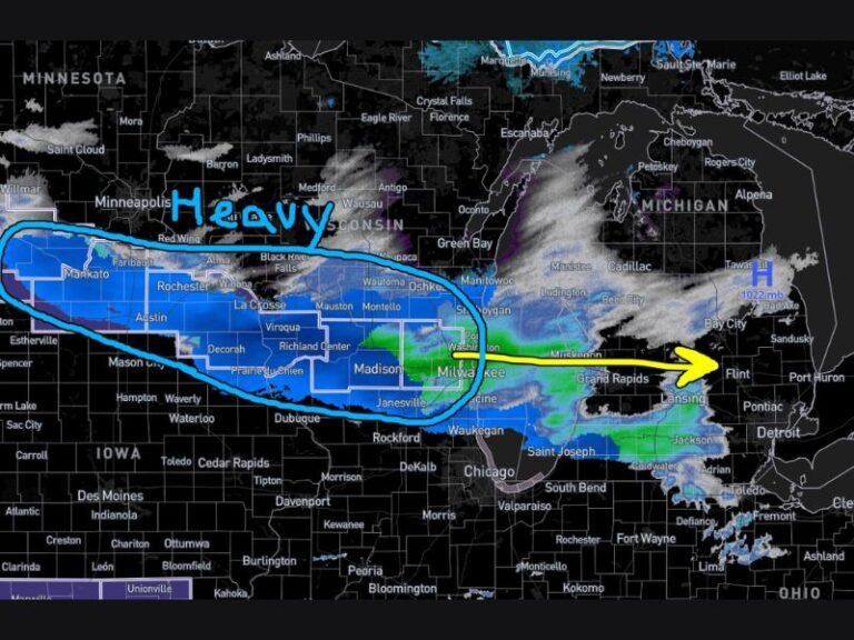
The map shows the atmospheric pattern responsible for early-January warmth breaking down over the central United States, allowing colder air to spill south and east. Minnesota, Wisconsin, Michigan, Iowa, Illinois, Indiana, and Ohio sit firmly within the core of this cooler pattern, with Missouri, Kansas, and Nebraska also trending colder than normal.
This marks a clear shift away from persistent ridging that kept temperatures elevated during the first half of the month.
What Temperatures Will Feel Like Across the Impacted States
As this colder pattern settles in, daytime highs across the Midwest and Great Lakes are expected to run cooler, with fewer warm, spring-like afternoons. Morning lows will turn noticeably colder, especially in northern and interior locations where the cold anomalies are strongest.
While this does not indicate extreme Arctic cold or nonstop winter storms, it does reflect a return to conditions more typical for mid-January in these states.
Why the Second Half of January Looks Different
The temperature anomaly map highlights a broad swath of below-normal air centered over the Midwest and Great Lakes, contrasted by lingering warmth farther south. This configuration supports a sustained cooler trend, rather than a brief cold snap, as the month progresses.
Meteorologists have been watching this transition closely, and the signals now consistently point toward January behaving more like January across the central U.S..
What This Does — and Does Not — Mean Going Forward
This pattern shift means cooler days, colder mornings, and fewer warm breaks for states in the Midwest and Central Plains. However, it does not automatically translate to major snowstorms or extreme cold, as precipitation and storm placement will depend on additional short-term systems.
SaludaStandard-Sentinel.com will continue tracking how this evolving winter pattern impacts the central United States as January progresses and whether colder air eventually expands farther south or east.