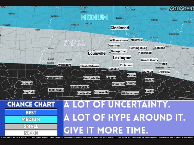
Unseasonable Warmth Builds Across the Texas, Southern and Eastern United States as Mid-January Pattern Turns Abnormally Mild
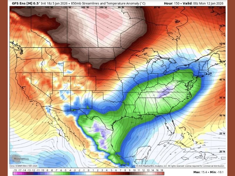
SOUTHEASTERN UNITED STATES — A striking temperature anomaly pattern is developing across much of the country heading into mid-January, with forecast data showing well-above-average warmth expanding across the South and East while colder air remains largely locked across the northern tier. The map highlights 850-millibar temperature anomalies, a key atmospheric level used to assess large-scale air mass behavior rather than day-to-day surface forecasts.
What the Temperature Anomaly Map Shows
The data illustrates a pronounced north-south contrast in air masses across the United States. Colder-than-average air remains entrenched across parts of the Northern Plains and Upper Midwest, while a broad plume of warmer-than-normal air surges northward from Texas through the Deep South and into the Eastern Seaboard.
These anomalies suggest that the jet stream is positioned in a way that allows mild Gulf-origin air to dominate much of the southern half of the country, suppressing typical mid-January cold across large portions of the Southeast.
Why 850-Millibar Temperatures Matter
While this is not a surface forecast, 850-mb temperatures provide insight into pattern direction and persistence. When warmth is this expansive at mid-levels of the atmosphere, it often translates to above-average surface temperatures, especially if the pattern holds for several days.
This setup helps explain why winter cold has struggled to gain traction across the South, even as colder air remains present farther north.
Southeast and East Coast Stand Out
The most notable warmth appears across Texas, the Deep South, and the Eastern United States, with anomalies extending up the East Coast. This indicates a suppressed winter pattern, where cold fronts may arrive but struggle to maintain long-lasting impacts.
For January, this level of warmth is unusual but not unprecedented, particularly during winters dominated by strong jet stream ridging over the Southeast.
What This Does — and Does Not — Mean
This pattern does not guarantee specific temperatures or daily conditions, nor does it eliminate the possibility of brief cold snaps. However, it strongly suggests that sustained winter cold remains unlikely across the South and Southeast in the near term, with any colder periods likely to be short-lived.
As long as this configuration persists, winter weather threats remain limited, and temperature swings will continue to favor milder conditions over prolonged cold.
SaludaStandard-Sentinel.com will continue monitoring how long this anomalous pattern holds and whether meaningful changes emerge later in January.