January 10 Forecast Signals Elevated Severe Weather Risk Across Mississippi as Deep South Pattern Draws Increased Attention
MISSISSIPPI — Forecast guidance is beginning to highlight an elevated signal for severe weather across parts of the Deep South, with Mississippi emerging as one of the areas drawing early attention as January 10 approaches. While the event remains several days away, the broader atmospheric pattern being shown is one that forecasters say deserves careful monitoring rather than dismissal.
At this stage, the data does not confirm a specific outbreak, but it does suggest a setup that has produced impactful weather in the past, especially during mid-winter periods that are often underestimated.
Developing Pattern Raises Early Concerns
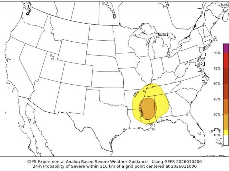
The graphic shared with the forecast highlights a zone of increased severe weather probability centered over portions of the central Gulf Coast and lower Mississippi Valley. Mississippi falls within the area showing a meaningful signal, indicating conditions could become supportive of organized thunderstorms if trends continue.
Forecasters emphasize that early signals like this are not guarantees, but they often serve as the first indication that the atmosphere may be aligning in a way that supports damaging weather.
Historical Context Underscores the Risk
One reason this setup is being taken seriously is its similarity to past January events. On January 11, 2020, a severe weather outbreak produced seven tornadoes across Mississippi, resulting in widespread damage, injuries, and multiple fatalities.
Events like that serve as a reminder that January is not an off-season for severe weather in the South, particularly when strong temperature contrasts and active storm tracks are present.
What Forecasters Are Monitoring Closely
Meteorologists are closely watching several evolving factors that could determine how impactful this system becomes. These include increasing signals for severe storms, the potential for damaging straight-line winds, and the possibility of tornado development if instability and wind shear align.
The concern at this point is not any single model run, but the overall consistency of the pattern and whether upcoming forecasts continue to reinforce the same signal.
No Panic, But Preparation Is Encouraged
Forecasters are clear that this information is not meant to cause alarm, but rather to encourage awareness. Early January severe weather events often occur overnight or during times when people may not be actively monitoring conditions.
Residents are encouraged to ensure they have reliable ways to receive weather warnings, especially methods that can alert them during overnight hours when severe weather can be most dangerous.
Forecast Confidence Will Improve With Time
As January 10 gets closer, confidence will increase regarding location, timing, and intensity. Additional model runs and ensemble guidance will help clarify whether this setup becomes a high-impact event or remains a lower-end threat.
For now, the key message is that Mississippi is within an area showing elevated severe weather signals, and continued monitoring over the coming days will be important.
SaludaStandard-Sentinel will continue to track this developing situation and provide updates as new data becomes available.