Developing Late-Week Storm System May Bring Winter Weather North and Severe Storm Risk South as Track Remains Uncertain
SOUTH CAROLINA — Forecast models are beginning to signal the development of a large, organized storm system later this week, possibly around Friday, that could impact multiple regions of the United States. Meteorologists caution that while the system appears increasingly likely to form, its exact track and intensity remain uncertain, which will ultimately determine where the most significant impacts occur.
Early guidance suggests this system could deliver a wide range of weather hazards, including winter weather on the colder northern side and a risk of severe storms across the warmer southern sector.
What Models Currently Show About the System
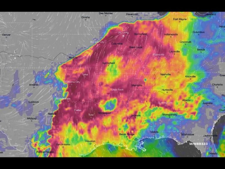
According to current model projections, an organized surface low may develop by late week, with indications pointing toward Friday as the key time frame. The system appears capable of producing a sharp temperature contrast across its path, setting the stage for very different weather outcomes depending on location.
Forecasters emphasize that the exact storm track is not yet locked in, and even small shifts north or south could dramatically change where snow, rain, or severe weather ultimately occur.
Winter Weather Potential on the Northern Side
On the colder side of the system, guidance highlights a corridor where winter weather could develop, including the possibility of heavy snow. The placement of this zone is still uncertain, as it depends on where the surface low tracks and how cold air is positioned at the time the system intensifies.
If the storm tracks farther south, winter weather could expand. If it shifts north, snowfall potential may be more limited. At this stage, confidence in exact snowfall locations remains low.
Rain and Severe Storm Risk on the Warm Side
South of the storm’s center, models indicate a region favorable for rain and potentially strong to severe thunderstorms. This area appears tied to the warm sector of the system, where moisture and instability could increase if the storm strengthens as projected.
While severe weather is not guaranteed, forecasters note that the setup bears watching, particularly if the system deepens and tracks in a way that enhances wind shear and storm organization.
Why Forecast Confidence Is Still Limited
Meteorologists stress that this forecast remains several days out, and long-range model runs often change as new data becomes available. At this point, the system is best described as a pattern worth monitoring rather than a confirmed event.
Future model runs will help determine whether the storm becomes more defined, weakens, or shifts in a way that reduces impacts altogether. Confidence will improve as the event moves closer.
What Residents Should Do Now
Residents should stay aware of updates over the coming days, especially as forecast confidence increases. No immediate action is needed at this time, but this system has the potential to bring impactful weather depending on how it evolves.
SaludaStandard-Sentinel will continue to track this developing situation and provide updates as new forecast information becomes available.