Georgia Weather Models Hint at Possible Snow Chance for January 7–9, But Forecast Confidence Remains Low
GEORGIA — New weather model data released this afternoon is showing a hint of a possible snow chance somewhere in the Georgia region during the January 7–9 timeframe, but forecasters emphasize that the signal is weak and nowhere near reliable at this stage.
Early raw output from the Canadian (CMC) and European (ECMWF) models shows snow potential, while the GFS model shows no snow at all. Despite those mixed signals, none of the ensemble guidance from any of the global models currently shows meaningful agreement that a winter event will develop.
What the Models Are Showing Right Now
Meteorologists reviewing the latest data note that only some deterministic runs are displaying snowfall across parts of north Georgia, while ensemble spreads remain poor, indicating a lack of confidence.
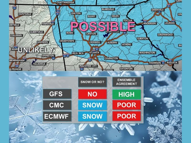
According to the comparison chart:
- GFS: No snow, high ensemble agreement
- CMC: Snow shown, poor ensemble agreement
- ECMWF: Snow shown, poor ensemble agreement
This combination suggests that while a few model runs may appear exciting for snow enthusiasts, the overall scientific support behind the idea is currently very weak.
Snow Signal for January 7–9: What It Really Means
A highlighted map from the North Georgia Weather Authority labels portions of north Georgia as “POSSIBLE” for snow, with areas farther west leaning “UNLIKELY.”
Forecasters stress that the map is not a storm prediction and should not be interpreted as a confirmed snow event. Instead, it reflects a low-confidence early indicator that winter weather could be worth monitoring over the next several days.
Key Takeaway for Georgia Residents
Experts caution that maps showing snowfall totals or impacts based on today’s runs mean nothing yet. Snow forecasting in the Southeast is highly sensitive to small shifts in atmospheric patterns, and confidence typically does not improve until much closer to the event window.
For now, the situation is simple:
A snow chance is possible, but not reliable — and no agreement exists among major models.
Georgia residents should continue monitoring updates as new model cycles arrive and ensemble patterns begin to clarify. Stay updated on regional weather impacts at SaludaStandard-Sentinel.com.