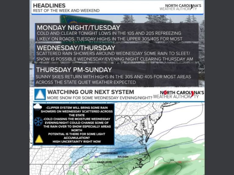
California Storm Threat Intensifies As New System Hits Burn Scars, Saturated Ground, And High-Risk Hillsides
CALIFORNIA — A powerful multi-day storm system is moving across the state, and officials warn the greatest danger may not come from the heaviest rainfall, but from the fragile landscape the storm is hitting. Large portions of California remain weakened from recent wildfire seasons and previous storms, setting the stage for landslides, debris flows, and flooding that may unfold even after the rain stops.
Why This Storm Is Different
Forecasters emphasize that this is not a routine winter storm. The system is pushing into areas still scarred from years of intense wildfires, where the natural stability of the land has not returned. Burned soil sheds water instead of absorbing it, root systems that once anchored hillsides are missing, and slopes can collapse hours or even days after rainfall ends. These delayed threats are why California often sees its most destructive mudslides after skies have cleared.
Burn Scars And Saturated Land Increase Risk
The storm is moving through terrain already weakened by multiple factors working together. Experts highlight several urgent concerns:
• Burned landscapes that repel water
• Loss of stabilizing roots on hillsides
• Slopes capable of failing suddenly and silently
• Debris flows that can surge without warning
• Ground saturated from earlier storms
• Heavy snow loading above 6,000 feet
• High rivers and fast-moving runoff
• Infrastructure not designed for continuous storm stacking
These overlapping conditions mean that impacts may arrive out of sequence. A neighborhood might see minimal rainfall yet experience dangerous debris flow hours later due to activity upslope.
Storm Duration Adds To The Danger
Meteorologists say the storm retains significant energy not just in rainfall totals, but in longevity. Rather than brief bursts of weather, this system is persisting across multiple days — the exact pattern that burn scar terrain reacts to most dangerously.
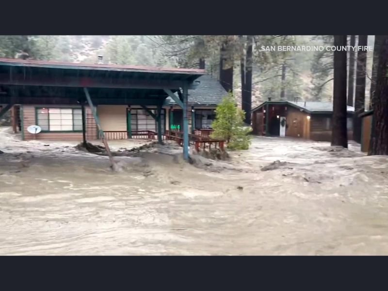
The widely shared image from San Bernardino County Fire shows fast-moving floodwater engulfing structures, with muddy runoff flowing like a river across residential areas. Officials say similar activity is possible in other hillside and canyon communities.
What Residents Should Watch For
Authorities are urging residents — especially those living near canyons, creeks, foothills, or burn areas — to stay vigilant long after rainfall lets up. Key safety steps include:
• Monitoring slopes for sudden movement or cracking
• Avoiding canyon roads during clearing periods
• Watching for fast-developing debris flows
• Staying aware of rising river gauges
• Following local emergency alerts closely
Officials stress that this is not about panic but preparedness. Persistent storms interacting with a changed landscape often create risk long after the main system moves through.
Looking Ahead
While heavy rain and mountain snow continue, the more critical hazards may emerge in the days that follow. California’s emergency teams remain on alert, and residents are urged to take every advisory seriously, especially in high-risk areas where landslides and mudflows historically occur with little warning. Stay aware. Stay safe. Visit SaludaStandard-Sentinel.com for continuing updates on major weather impacts across the U.S.