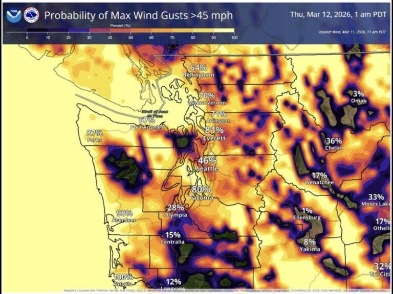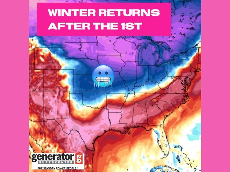
Winter Pattern Set to Return After January 1 Across Oklahoma, Kansas, Missouri, Arkansas, and the Central United States
UNITED STATES — A major shift back to colder conditions is expected shortly after the New Year as forecast models show winter temperatures surging southward across Oklahoma, Kansas, Missouri, Arkansas, and neighboring central states. The unusually warm stretch leading up to the holiday appears likely to end quickly as a broad zone of colder-than-normal air pushes into the region.
A Significant Temperature Drop Is Expected
Meteorologists tracking long-range model guidance report a strong signal for a notable cooldown beginning just after January 1, driven by a deeper push of Arctic air sliding out of the northern Plains. The map imagery shared by multiple forecasting outlets shows a wide region of deep blue and purple shading covering the central United States, indicating temperatures dropping well below seasonal averages.
States including Oklahoma and Kansas appear positioned near the core of the incoming cold, with surrounding areas of Missouri, Arkansas, Iowa, and Nebraska also likely to experience a pronounced shift after a period of unusually mild December weather.
Warm December Likely Ends Abruptly
This transition follows a December stretch that has been unusually warm for much of the region, with highs running 15–25 degrees above normal at times. Forecasters note that this pattern was unlikely to last, and the New Year’s pattern change has been increasingly visible in ensemble models over the past several days.
Even though exact temperature numbers have not yet been finalized, early projections indicate the first weekend after January 1 could bring:
- Much colder daytime highs
- Widespread overnight freeze potential
- A push of Arctic air into central and southern states
Precipitation Details Remain Uncertain
At this stage, meteorologists emphasize that the temperature change is the most reliable part of the forecast. There are currently no firm projections regarding snow, ice, or rainfall associated with the incoming cold pattern. Any potential winter precipitation risks will become clearer as updated model runs arrive later this week.
Residents Should Prepare for a Quick Change
While the forecast does not currently indicate extreme or dangerous cold, the shift will be significant enough for residents to notice a fast return to more typical winter conditions. Forecasters advise staying updated through the holiday weekend as more details emerge. For continuing updates and reliable coverage on weather changes heading into early January, visit SaludaStandard-Sentinel.com.