Arctic Blast Expected to Hit the South as Alabama, Georgia and the Carolinas Brace for a Sharp Temperature Crash Dec. 28–31
SOUTHERN UNITED STATES — A major temperature swing is on the way for Alabama, Georgia, and the Carolinas as a powerful cold-air mass is forecast to plunge southward between December 28 and December 31, bringing some of the coldest conditions the region has seen in weeks.
A Sudden Pattern Flip Will Send Temperatures Dropping
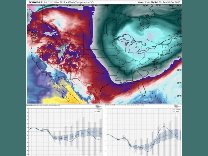
Weather models show both the Arctic Oscillation (AO) and North Atlantic Oscillation (NAO) turning strongly negative just before New Year’s weekend. When these two atmospheric patterns shift together, cold air often pushes aggressively into the eastern half of the United States — and this time, the South is directly in the line of fire.
Meteorologists say this cold isn’t expected to “ease in.” Instead, it’s expected to surge southward abruptly, dropping temperatures by double digits across multiple states.
What Residents Should Expect Dec. 28–31
Forecast guidance suggests a four-day stretch of noticeably harsher conditions, including:
- Much colder mornings and near-freezing wind chills
- Stronger winds making homes feel colder
- Increased strain on heaters and HVAC systems
- Icy-feeling air despite a lack of actual winter precipitation
- Cars struggling on cold mornings due to rapid drops in temperatures
While the system is not expected to bring widespread snow or ice to the Deep South, the sudden arrival of cold air will feel dramatically different from the unusually warm pattern the region has been experiencing.
Cold Arrives in Waves Before a Strong Surge on Dec. 30–31
Model maps indicate that the sharpest drop may happen overnight on December 29 into December 30, when temperatures quickly fall behind a fast-moving cold front.
Residents stepping outside early in the morning may feel temperatures that seem “out of nowhere,” especially after a month of above-normal warmth. The coldest period appears to be December 30 and December 31, with some locations dropping 20–30°F compared to earlier in the week.
No Significant Winter Storm Risk at This Time
Although the incoming air mass will be strong, there is no current indication of snow, ice, or widespread winter precipitation in Alabama, Georgia, or the Carolinas. The main impact will be the temperature crash and the wind-driven chill.
Forecasters will continue monitoring the setup in case moisture aligns with the arriving cold air, but for now, the primary concern remains a sharp drop in temperatures to close out the year.
Prepare for a Much Colder Holiday Weekend
The South has enjoyed unusually warm weather throughout December — but that pattern ends abruptly as 2026 approaches. Residents are encouraged to make sure heaters are working properly, bring pets indoors, and prepare for colder mornings that may continue into the first few days of January. Stay updated with the latest weather developments at SaludaStandard-Sentinel.com.