Midwest Experiences Colder Temperatures Than the North Pole as Arctic Blast Drops Readings 40°F Below Normal
MIDWEST — In a remarkable turn of weather extremes, parts of the Midwest were colder than the North Pole on Sunday as an intense Arctic blast plunged temperatures across the central United States. Meteorologists reported readings as low as 40°F below normal, with some areas struggling to climb above 0°F during the day.
Unprecedented Temperature Anomalies Across the Hemisphere
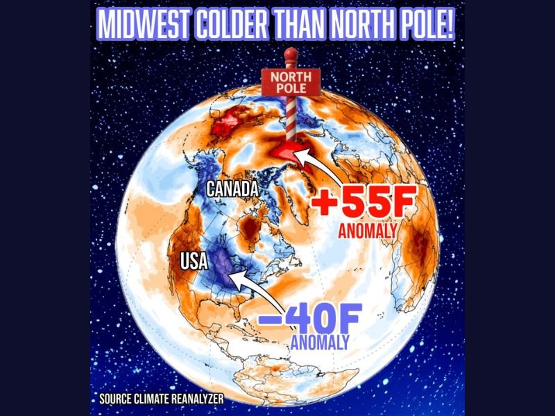
According to data from Climate Reanalyzer, the Midwest’s deep freeze coincided with unusually mild conditions in the Arctic, where temperatures ran an astonishing 55°F above average in certain regions. The result was a striking contrast on global temperature maps — a frozen heart across the U.S. heartland, while the North Pole basked in relative warmth.
“This is one of those rare atmospheric setups where the Arctic feels springlike compared to parts of America,” said meteorologist Chris Jones. “It’s a perfect example of how disrupted jet stream patterns can flip the temperature map upside down.”
How the Arctic Block Triggered the U.S. Deep Freeze
Meteorologists attribute the Midwest’s extreme cold to a high-pressure block over the Arctic, which disrupted the polar vortex and forced a large mass of frigid air southward into the continental United States. Meanwhile, the displaced polar air allowed milder air to surge northward, warming the Arctic region far above seasonal norms.
The phenomenon is part of a larger atmospheric wave pattern known as “troughs and ridges,” where cold and warm air masses oscillate north and south. This dynamic movement can cause regions in the mid-latitudes — like the Upper Midwest and Great Plains — to experience sudden, severe cold outbreaks, even while the Arctic warms.
Record-Low Temperatures Across the Midwest
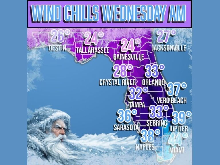
Several Midwest states, including Minnesota, Iowa, Wisconsin, and the Dakotas, reported temperatures dipping below -20°F in the coldest areas. Wind chills made it feel even more brutal, ranging from -30°F to -45°F at times.
“This wasn’t just a cold snap — it was a historic temperature inversion,” Jones explained. “When the North Pole is warmer than Chicago, it shows how volatile our weather systems can become during these Arctic intrusions.”
The Science Behind an ‘Upside-Down’ Winter
Experts emphasize that while it might seem paradoxical, these temperature inversions are not new. The waviness of the jet stream — intensified by Arctic warming — can send extreme cold farther south and allow warm air to push northward into polar regions.
“As the Arctic warms faster than the rest of the planet, these atmospheric disruptions become more pronounced,” Jones said. “It’s a reminder that cold outbreaks and warming trends can coexist in a complex climate system.”
Impact Across the Region
The deep freeze has led to dangerously low wind chills, frozen infrastructure, and increased energy demand across the Midwest. Emergency officials are urging residents to limit outdoor exposure, protect plumbing, and check on vulnerable neighbors.
Utility companies across the region have also issued statements encouraging customers to conserve energy and report outages immediately, as demand spikes put strain on regional power grids.
Looking Ahead: Brief Relief on the Horizon
Forecasters say the bitter cold will gradually ease later in the week as milder Pacific air moves eastward, though temperatures are expected to remain below normal for several more days.
“This is winter at its most dramatic,” Jones said. “We’ve gone from polar extremes to a full atmospheric balancing act between the North Pole and the Midwest.”
For continued national and regional weather coverage, visit SaludaStandard-Sentinel.com.