Washington Mountains Could See Up to 100 Inches of Snow This Week as Major Winter Storm Targets High Elevations
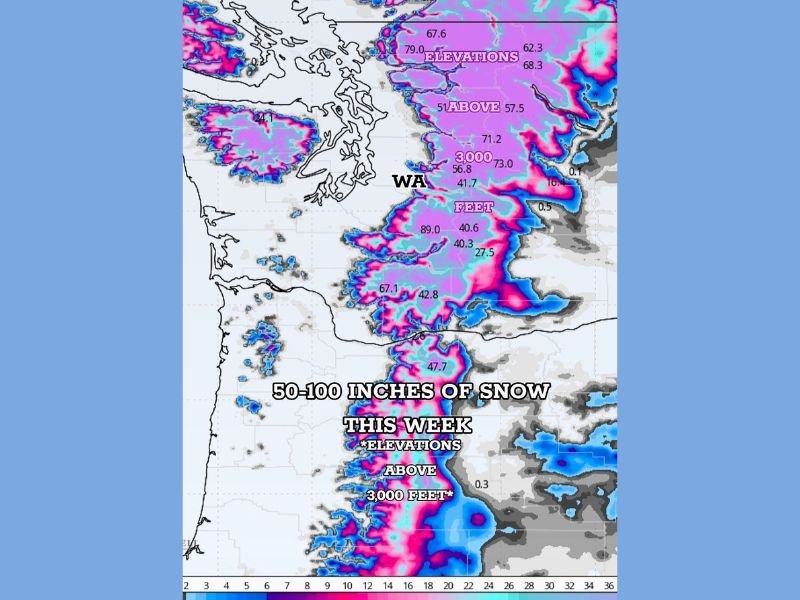
WASHINGTON — A powerful winter storm system is poised to deliver massive snowfall totals across the mountains of Washington state this week, with forecasters warning that elevations above 3,000 feet could see between 50 and 100 inches of snow by the weekend. The National Weather Service (NWS) is monitoring the developing system closely and is expected to issue a detailed statement later this evening.
Heavy Mountain Snow Expected to Begin Late Tuesday Night
Snowfall will begin to ramp up late Tuesday into early Wednesday across western and northern Washington, spreading through the Cascades and Olympic Mountains by midweek. Forecast models indicate continuous rounds of moisture-laden Pacific air colliding with cold mountain air, producing near-blizzard conditions at higher elevations.
“This is a textbook setup for major mountain snow,” meteorologist Chris Jones explained. “Moisture flow from the Pacific will be relentless, and with snow levels staying near 3,000 feet, accumulation will stack up fast.”
By Saturday afternoon, much of the mountainous terrain is expected to total between four and eight feet of snow, with isolated peaks possibly exceeding 100 inches.
Travel Through Mountain Passes Could Become Extremely Dangerous
The storm will create hazardous travel conditions across key mountain corridors, including Snoqualmie, Stevens, and White Passes, where visibility may drop to near zero during heavy snow bands. Officials warn that roads could become impassable for periods of time, and avalanche risks will rise significantly as snow piles up.
Residents and travelers are urged to check NWS alerts and Washington State Department of Transportation (WSDOT) updates before attempting any mountain travel. Chains and emergency supplies are strongly advised for all high-elevation routes.
“This is not a quick storm,” Jones added. “It’s a multi-day event that’s going to challenge anyone trying to get over the passes. If you don’t have to travel in the mountains this week, don’t.”
Lower Elevations to See Rain and Gusty Winds
While the heaviest snow will remain confined to higher elevations, lower valleys and foothills across western Washington can expect cold rain and gusty winds through the second half of the week.
Rainfall totals could reach 2 to 3 inches in parts of the Puget Sound area, leading to minor flooding concerns in areas with poor drainage. Temperatures will stay in the upper 30s to mid-40s, making for chilly, wet conditions at lower elevations.
Forecasters Eye Continued Storm Activity Into the Weekend
Meteorologists say the current system may be followed by another round of snow over the weekend, as Pacific storm energy continues to push inland. By that time, the highest peaks could have snowpack exceeding eight feet, adding to an already impressive early-season total for Washington’s mountains.
“This is great news for ski resorts but tough news for travel,” Jones said. “The consistent snow above 3,000 feet will help build a strong base for winter recreation but also raises avalanche risks for backcountry adventurers.”
Preparation Urged Before Storm Intensifies
Residents near mountain areas are urged to prepare for extended periods of heavy snow, ensure they have access to emergency supplies, and stay tuned to local weather updates.
The National Weather Service is expected to issue special statements later tonight outlining the full scope of the storm and its potential impacts.
For continued weather coverage and safety updates, visit SaludaStandard-Sentinel.com.