Iowa Sees Widespread Snowfall with Up to 5 Inches Reported as Storm Gradually Tapers Off Sunday Afternoon
DES MOINES, IOWA — A widespread winter storm blanketed much of Iowa on Sunday, dropping 2 to 5 inches of snow across central and southern parts of the state before gradually tapering off through the afternoon. The system marks a significant turnaround after last week’s “dry air disaster,” when forecasted snow largely failed to materialize.
Snow Blankets Central and Southern Iowa
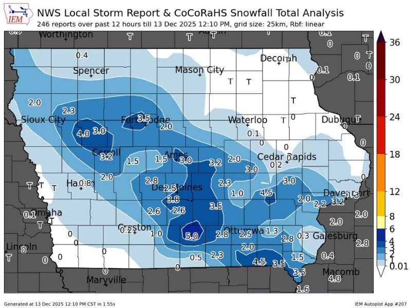
According to data from the NWS Local Storm Report and CoCoRaHS Snowfall Total Analysis, the heaviest snowfall occurred in a swath stretching from Sioux City through Fort Dodge, Des Moines, and Creston, where totals ranged from 3 to 5 inches. The Des Moines metro area reported around 3 to 4 inches, while southern Iowa counties near Ottumwa and Albia saw 2 to 3 inches.
Meteorologist Maurer noted that the event’s forecast verified well, saying, “After Thursday’s dry air issue, this system performed exactly as expected.” He added that snow will continue to taper off from northwest to southeast through the late afternoon as the system exits the region.
Travel Conditions Slowly Improving
Roads across central and western Iowa were slick through midday, with reports of reduced visibility and patches of ice. The Iowa Department of Transportation urged drivers to use caution, as temperatures hovering around freezing allowed for quick re-icing of treated surfaces.
Crews have been working since early morning to clear highways and major interstates, with plows focusing on Interstate 35 and Interstate 80, where several minor accidents were reported. Conditions are expected to gradually improve by evening as snow diminishes and winds calm.
Snow Totals by Region
Preliminary reports show the following accumulations:
- Creston: 5.0 inches
- Fort Dodge: 3.5 inches
- Des Moines: 3.8 inches
- Carroll: 4.0 inches
- Ottumwa: 2.8 inches
- Sioux City: 2.3 inches
- Waterloo and Cedar Rapids: Less than 1 inch
While the heaviest snow stayed confined to the central and southwest corridor, lighter accumulations reached as far east as Cedar Rapids, Dubuque, and Davenport, where less than half an inch was observed.
Looking Ahead
Forecasters expect cold and dry conditions to settle over Iowa overnight as the storm exits into the Midwest. Temperatures will drop into the teens by Monday morning, with a mix of sun and clouds through the start of the workweek.
Meteorologists say another weak system could pass through midweek but emphasize that no major storms are expected in the immediate forecast.
Residents are encouraged to allow extra travel time and remain cautious of icy patches, especially overnight as temperatures continue to fall.
For continued weather coverage and local updates, visit SaludaStandard-Sentinel.com.