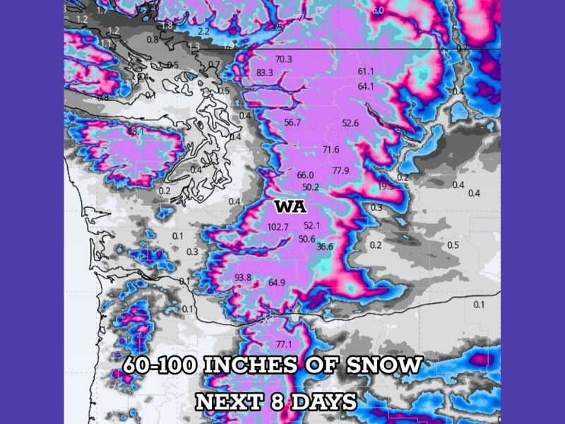
Washington State Faces Extreme Mountain Snowfall as Forecasts Call for 60–100 Inches Over the Next 8 Days
WASHINGTON — After enduring a period of record-setting flooding, Washington is now preparing for a dramatic shift in hazards as an enormous amount of mountain snowfall is forecast to arrive over the next week. Meteorologists warn that many higher-elevation regions across the state could receive 60 to 100 inches of snow, marking one of the most significant multi-day snowfall events of the season.
Major Snowfall Expected in the Cascades and Higher Elevations
Forecasters say this looming snow event is being driven by a persistent series of storm systems expected to push moisture into the Pacific Northwest.
Key projections show:
- 60–100 inches of snow likely in the Cascades and surrounding mountain terrain
- Higher ridgelines and peaks potentially exceeding 100 inches
- Widespread heavy snow coverage based on deterministic and ensemble modeling averages
- Significant snowpack recovery following earlier record rain and flooding
These snow totals reflect a blend of multiple forecast models, providing stronger confidence in the high-impact nature of the event.
Recent Flooding Heightens Concerns Ahead of New Storm Cycle
This transition from severe rainfall to extreme snowfall occurs just days after Washington experienced widespread flooding that broke historical river-stage records in several counties.
The sudden shift brings new challenges:
- Rapid snow accumulation that may stress mountain infrastructure
- Increased avalanche danger as deep layers build quickly
- Travel risks for passes such as Snoqualmie, Stevens, and White Pass
- Potential for road closures and chain requirements
- Heavy snow load impacts on roofs and power lines in higher communities
Officials urge residents and travelers to monitor conditions closely as the region moves into a week-long period of winter storm hazards.
What Residents and Travelers Should Prepare For
Meteorologists recommend the following precautionary steps:
- Plan for major disruptions on mountain highways and ski routes
- Expect limited visibility and hazardous driving conditions during peak snowfall
- Prepare for possible power outages in remote, elevated areas
- Stay alert for avalanche advisories in backcountry regions
- Avoid unnecessary travel into higher elevations during the heaviest snow periods
Emergency officials emphasize that communities depending on mountain passes for supply routes may need to prepare for delays.
A Critical Winter Weather Week for the Pacific Northwest
With snowfall rates projected to be intense and persistent, Washington’s upcoming 8-day weather window will play a major role in both snowpack formation and winter hazard management across the state.
Residents, skiers, and commercial drivers are encouraged to follow real-time updates from the National Weather Service and state transportation agencies, as forecast refinements are expected throughout the week.
Stay Connected
How is this developing winter pattern affecting your region? Share your updates and community insights with us at SaludaStandard-Sentinel.com to help keep your neighbors informed.