Gulf Coast States Texas, Louisiana, Mississippi, Alabama, and Florida Expected to See Early Signs of Winter Pattern While Major Cold Threat Still Points to January
UNITED STATES — New long-range weather data suggests that the Gulf Coast states of Texas, Louisiana, Mississippi, Alabama, and Florida may begin seeing hints of winter conditions, but meteorologists emphasize that January remains the primary month of concern for meaningful cold outbreaks. The latest model graphics trending across social media are not forecasting imminent winter emergencies for December; instead, they represent early atmospheric signals that typically precede the region’s true winter impacts.
Meteorologists Stress That December Is Not the Gulf Coast’s Main Cold Season
Forecasters note that the Gulf Coast historically sees its most impactful cold periods in January, not December.
The current graphics showing snow to the north and cold intruding southward are described as “early indicators, not final outcomes.”
Experts explain that:
December often produces false alarms, with temperatures appearing poised to drop substantially only for the coldest push to delay until after New Year’s.
January, by contrast, brings the highest risk of pipe-bursting freezes, damaging frost events, and deep intrusions of Arctic air.
This aligns with the region’s longstanding pattern: the Gulf Coast’s most significant winter episodes occur late in the season rather than early.
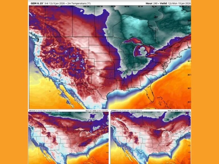
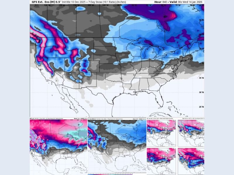
Current Model Graphics Show an Atmospheric Pattern Leaning Colder
The model images circulating this week reflect a growing theme:
Cold air is expanding southward across the central United States throughout late December, though not aggressively enough to threaten the Gulf Coast with severe impacts just yet.
Meteorologists describe this as:
*Cold fronts lurking,
Snow tracks shifting south, and
Early atmospheric cues consistent with what often develops into more significant January cold.
The gray and blue shading over the central United States on ensemble model maps represents potential energy and pattern evolution, rather than a December snow or freeze forecast for the Gulf Coast states.
January Remains the Main Concern for the Gulf Coast
According to forecasters, the real risk window aligns with mid-January, when:
Pipes are most vulnerable,
Landscape plants historically take damage, and
Homes and pets require additional cold-weather protection.
These are the “main character” winter events the region remembers — not the mild early-season dips that often fade as quickly as they arrive.
Meteorologists caution residents against mistaking the current early model signals for direct forecasts. Instead, these signals suggest that the pattern is preparing to shift toward a more winter-like setup as January approaches.
Residents Encouraged to Stay Aware but Not Alarmed
While early December and late December can produce temporary cool spells, the Gulf Coast rarely experiences high-impact winter events before January.
Forecasters emphasize that:
Anything before January is bonus footage, not the main storyline.
The risk of impactful winter weather increases sharply after New Year’s.
A stronger cold pattern taking shape in the northern and central United States reinforces the need for Gulf Coast residents to monitor forecasts more closely as January nears.
Residents noticing early weather shifts or tracking developing forecasts are encouraged to share updates and preparedness tips with the community at SaludaStandard-Sentinel.com.