Christmas Week Forecast Shows Cooler-Than-Normal Temperatures Across Texas, Oklahoma, Arkansas, Louisiana, Mississippi, Alabama, Georgia as Models Reject “Warm Christmas” Expectations
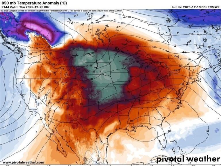
UNITED STATES — New long-range forecast data from both the GFS and European (EURO) models indicates that Christmas week will lean cooler-than-normal across Texas, Oklahoma, Arkansas, Louisiana, Mississippi, Alabama, Georgia, and Tennessee, challenging earlier assumptions that the South might experience a warm, spring-like holiday. Instead, model maps show a broad stretch of blue-coded cooler air lingering across the central and eastern United States on Christmas morning.
Models Show Clear Signal for Cooler Holiday Temperatures
While early-season chatter suggested a potential warm pattern, updated model runs depict a significantly different outcome.
Both the GFS and EURO simulations show widespread cool anomalies, with below-average temperatures stretching from the southern Plains through the lower Mississippi Valley and into the Southeast.
This trend does not signal a historic Arctic outbreak nor the coldest Christmas on record. However, forecasters note that it also does not resemble the warm “blow torch” scenario that some had anticipated.
Based on the latest model maps:
Texas, Oklahoma, and Arkansas are expected to remain shaded in cooler-than-average air.
Louisiana, Mississippi, Alabama, Georgia, and Tennessee show similarly persistent cool anomalies into Christmas morning.
Not Extreme Cold, but Not a Warm Holiday Either
Meteorologists describe the upcoming pattern as seasonal to slightly colder, pushing many Southern states into temperatures supportive of:
Sweater weather, jacket weather, and heater-running mornings, especially during early travel hours.
This means residents should anticipate a more traditional December feel, rather than the warm and humid conditions sometimes observed in recent years.
The pattern does not currently suggest:
A deep freeze
Arctic outbreak conditions
Coast-to-coast warmth
Instead, the evolving setup points to a middle-ground scenario, where colder air remains entrenched enough to prevent any widespread warm surge from dominating Christmas week.
Forecast Pattern Remains Flexible but Consistent
Forecasters emphasize that model tweaks are still possible, but the overall trend is clear:
The South is unlikely to experience a warm or spring-like Christmas this year.
The updated temperature maps show colder air “holding its ground” across much of the central and eastern U.S., preventing the type of warm-up that earlier long-range models briefly suggested.
While minor adjustments may occur as new data becomes available, the consistency between major models strengthens confidence in a cooler regional outcome for December 25.
Residents Should Prepare for Seasonally Cool Holiday Weather
With many Southern states preparing for holiday travel, outdoor gatherings, and end-of-year events, the shift toward cooler conditions is an important planning factor.
Residents across Texas, Oklahoma, Arkansas, Louisiana, Mississippi, Alabama, Georgia, and Tennessee should expect cool mornings, brisk winds at times, and typical winter conditions rather than an unseasonably warm holiday.
Readers noticing early hints of this cooling trend, or preparing for Christmas week weather impacts, are invited to share updates with the community at SaludaStandard-Sentinel.com.