Cold Front Set to Sweep Through Central Texas Early Sunday With Sharp Temperature Drop and Strong Wind Chills
TEXAS — A strong cold front is expected to move into Central Texas early Sunday morning, bringing a noticeable temperature drop, gusty north winds, and wind chills that will make conditions feel near freezing in cities such as Waco, Temple, and Killeen. While Saturday will offer mild weather, forecasters warn that the shift to colder air will be abrupt and short-lived before warmer temperatures return next week.
Mild Saturday Before the Front Arrives
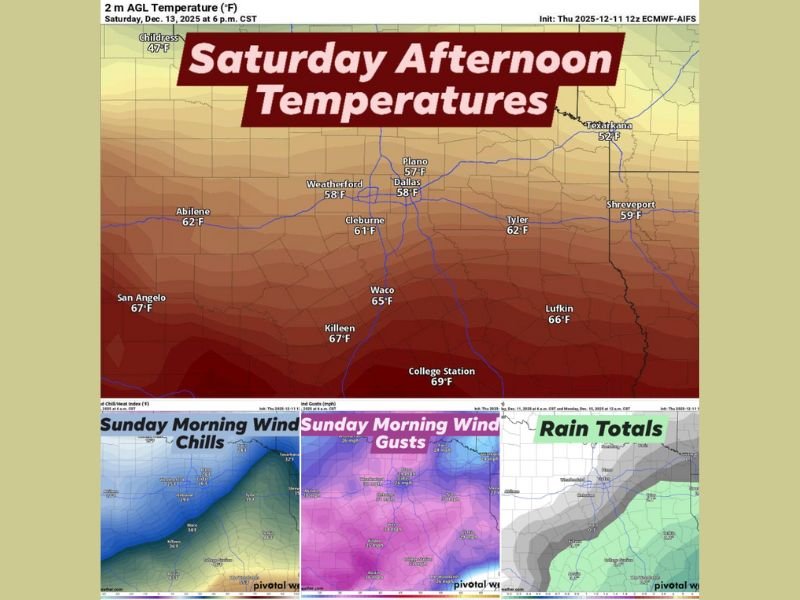
Forecast data shows Saturday will be relatively pleasant across Central Texas, with afternoon temperatures reaching the 60s in areas including Waco, Killeen, College Station, and San Angelo. However, forecasters note that cloud cover may limit heating, especially east of the I-35 corridor where skies could remain overcast through the day.
If clouds fail to clear, highs may only reach the 50s, particularly for locations farther east.
Cold Front Hits Early Sunday With Strong Wind Chills
A sharp change arrives early Sunday as the cold front pushes south. Morning readings are expected to hover around 40 degrees, but north winds over 30 mph will cause wind chills to feel much colder. Areas across Waco, Temple, and Killeen may experience conditions that feel near freezing, marking a significant contrast from the milder temperatures just 24 hours earlier.
The front is not expected to bring widespread Arctic air, but Central Texas will feel a brief surge of cold, dry air, strong enough to prompt residents to prepare for a chilly start to their Sunday.
Light Rain Possible, Mainly Southeast Toward the Brazos Valley
Light rain showers may occur as the front moves through, but coverage will be limited.
Best chances for measurable rain remain southeast into the Brazos Valley, including areas around College Station and Brenham. Even there, totals are expected to be minimal. The latest data trends drier overall, suggesting most locations will see little to no rainfall.
Cold Blast Will Be Short-Lived Before Christmas Warm-Up
Forecasters emphasize that this cold air mass will not linger long over Texas. Temperatures are expected to rebound in the days following the front, with a return to milder conditions as the state moves closer to Christmas. Sunshine and calmer winds will also help daytime highs climb back to more typical December levels.
Residents preparing for the weekend cold or monitoring local temperature changes are encouraged to share updates and experiences with the community at SaludaStandard-Sentinel.com.