Major Arctic Blast Forecast to Drive Dangerous Wind Chills Across Minnesota, Wisconsin, Michigan, Illinois, Indiana, Ohio, Iowa, Missouri, and the Great Lakes Region Next Weekend
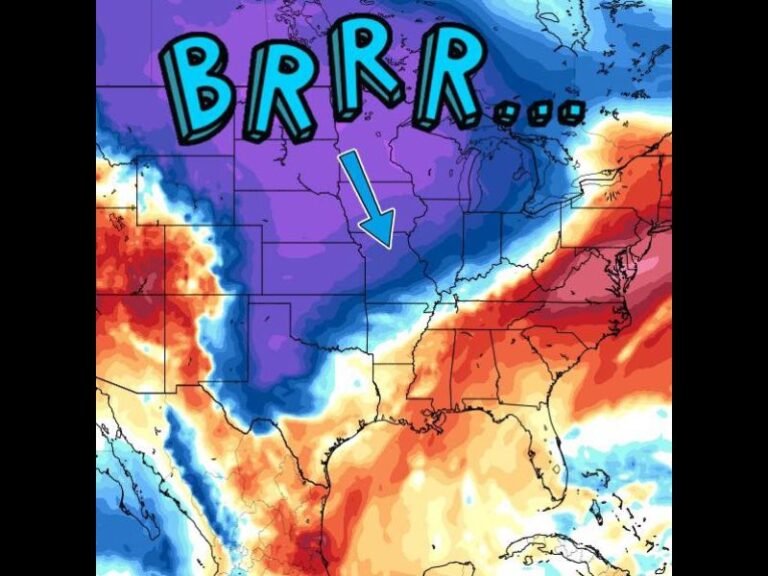
UNITED STATES — Forecasters are tracking a powerful Arctic air mass building in the Arctic Circle that is expected to surge southward next weekend, bringing the coldest wind chills of the season to Minnesota, Wisconsin, Michigan, Illinois, Indiana, Ohio, Iowa, Missouri, and much of the Great Lakes region. Meteorologists warn that the arrival of this strong cold front will open the door to dangerously low temperatures that could impact millions.
Models Show Significant Temperature Drop With Wind Chills Well Below Freezing
According to the latest Euro wind chill projections, the Arctic front will sweep through the Upper Midwest and Great Lakes, producing:
- Wind chills far below 0°F in Minnesota and Wisconsin
- Dangerously cold conditions across Michigan, Illinois, Indiana, and Ohio
- Rapid temperature crashes throughout Iowa and Missouri
- The potential extension of cold air into the Southern U.S. if the pattern deepens
Forecasters note that the coldest air appears centered over the Upper Midwest, where temperatures may drop sharply within hours of the front’s arrival.
Lake-Effect Snow May Intensify Behind the Arctic Front
In addition to the extreme cold, meteorologists warn that this system may enhance lake-effect snow bands downwind of the Great Lakes. The sharp temperature difference between the frigid air mass and the relatively warmer lake waters could trigger:
- Intense, localized snow squalls
- Rapid drops in visibility
- Hazardous road conditions
- Heavy accumulations in traditional lake-effect snow belts of Michigan, Ohio, Pennsylvania, and New York
Drivers across the region may face difficult travel conditions, particularly during evening and overnight hours after the front passes.
Forecasters Advise Residents to Prepare Early for Extreme Cold
Meteorologists emphasize that wind chills associated with this Arctic blast may reach levels that pose risks for frostbite and hypothermia in a short period of time. Residents across the Upper Midwest and Great Lakes should prepare for:
- Bitter cold mornings and evenings
- High energy demand as heating systems work harder
- Possible school or event impacts if temperatures fall into dangerous ranges
- Sudden ice formation on roadways following the frontal passage
Forecasters recommend finalizing winter readiness plans ahead of the weekend.
More Model Updates Expected as the Arctic Air Mass Strengthens
While confidence is high that a major cold outbreak will occur, the exact intensity and southern reach of the Arctic air will become clearer in upcoming model runs. Meteorologists will continue monitoring whether the cold extends deeper into the central or southern United States.
Residents across the Midwest and Great Lakes are encouraged to stay alert to updated forecasts.
How will this Arctic outbreak affect your weekend plans? Share your thoughts with us at SaludaStandard-Sentinel.com.