Central Iowa Hit by Intense Snow Band With 1-Inch-Per-Hour Rates as Major Winter Storm Moves Toward Des Moines
DES MOINES, IOWA — Central Iowa is in the grip of a powerful long-duration winter storm that began early Saturday, bringing heavy snow bands producing rates of up to one inch per hour across much of the region.
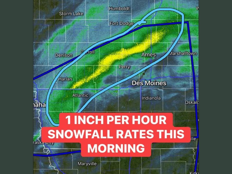
Meteorologists report that a strong zone of frontogenesis — where cold and warm air masses collide — has set up across central Iowa, triggering intense, steady snowfall that is expected to continue through the morning.
The heaviest snow bands are currently tracking through Ames, Perry, and Carroll, and will gradually pivot eastward toward Des Moines as the system progresses.
Snow Intensifies Across Central and Eastern Iowa
Weather radar shows a vivid yellow band of precipitation extending from Atlantic through Ames, signaling the heart of the snow-producing zone. This band of 40 dBZ reflectivity indicates moderate to heavy snowfall intensity, capable of quickly covering roads and reducing visibility to near zero at times.
The National Weather Service warns that snowfall totals could reach up to 12 inches (1 foot) across portions of central and eastern Iowa, with accumulation expected to spread into northwestern Illinois by Sunday afternoon.
“We’re seeing the kind of snow that makes travel extremely dangerous,” one forecaster said. “At one inch per hour, roads can become impassable within a short time frame if plows can’t keep up.”
Des Moines Faces Dangerous Travel Conditions
Des Moines and surrounding communities are expected to receive the brunt of the storm through the afternoon, with forecasters noting that the storm’s pivoting motion will keep the snow band nearly stationary for several hours.
Snow-covered roads, slick intersections, and reduced visibility have already led to multiple travel advisories across the state. Drivers are urged to stay off the roads unless absolutely necessary.
The Iowa Department of Transportation has issued alerts for rapid snow accumulation, warning that plow crews are working continuously but may fall behind during peak snowfall hours.
Regional Outlook: Illinois Next in Line
As the system slowly drifts eastward, eastern Iowa and western Illinois will begin to see increasing snowfall rates late Saturday into Sunday. By the time the storm exits, a broad swath from central Iowa to northern Illinois could see 6 to 12 inches of total accumulation.
Meanwhile, southern Iowa may experience a lighter snow mix or flurries, depending on how the storm’s southern edge develops.
Meteorologists expect temperatures to remain below freezing, ensuring that most of the snow sticks and creates hazardous conditions well into Sunday.
Safety and Preparedness
Residents across Iowa are urged to:
- Avoid unnecessary travel during peak snowfall hours.
- Keep emergency supplies in vehicles, including blankets, water, and flashlights.
- Allow extra time for snow removal and check on vulnerable neighbors.
Forecasters caution that the heaviest snow and lowest visibility will occur through Saturday morning before tapering to lighter snow overnight. However, wind gusts could cause additional drifting and reduced visibility even after the heaviest snow subsides.
Stay tuned for ongoing weather alerts and road condition updates on SaludaStandard-Sentinel.com, as this major winter storm continues to move east across the Midwest.