EURO Model Predicts Major Winter Storm: Up to 6 Inches or More of Snow Expected Across Midwest and Great Lakes Region
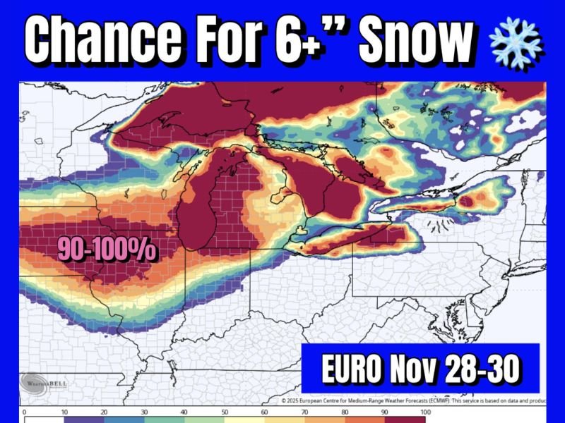
CHICAGO, ILLINOIS — A powerful early-season winter storm is taking aim at the Midwest and Great Lakes region this weekend, with the latest EURO ensemble forecast showing a 90–100% chance of 6 inches or more of snow for several states.
The snow system, expected to unfold between Friday, Nov. 28, and Sunday, Nov. 30, could bring heavy accumulations, strong winds, and hazardous travel conditions to a large stretch of the central United States.
High Confidence in Heavy Snowfall
According to the European Centre for Medium-Range Weather Forecasts (ECMWF) model, confidence is unusually high for widespread snowfall totals exceeding six inches across the Upper Midwest and Great Lakes basin.
The areas with the highest probability (90–100%) include:
- Northern Illinois (including the Chicago metro area)
- Southern Wisconsin
- Northern Indiana
- Lower Michigan
In these regions, the storm system is expected to deliver steady, wet snow that could persist for more than 24 hours, with some localized totals possibly exceeding 8 to 10 inches.
Meteorologists say the EURO model’s ensemble suite — which averages dozens of weather simulations — has remained remarkably consistent over multiple runs this week, increasing confidence in a significant snow event.
“This is shaping up to be the first true major winter storm of the season for the central U.S.,” forecasters said. “The probability of 6+ inches of snow across this wide an area this early is impressive.”
Timing and Development
The developing system will be driven by a strong low-pressure center moving eastward from the central Plains into the Great Lakes, pulling in moisture from the south and cold Arctic air from the north.
- Friday night: Light snow begins across Iowa and northern Illinois.
- Saturday: Heavier snow bands develop over Illinois, Wisconsin, and Michigan as the system strengthens.
- Sunday: The storm shifts eastward, bringing snow to Ohio and parts of Pennsylvania before tapering off.
High winds are also likely to accompany the storm, particularly around the Great Lakes, where gusts could exceed 35–40 mph, leading to blowing and drifting snow and near whiteout conditions at times.
Travel and Power Concerns
The National Weather Service is expected to issue winter storm watches and warnings as the event approaches. With holiday travel ramping up after Thanksgiving, road conditions may deteriorate rapidly across major highways including:
- Interstate 80 and 90 corridors
- I-94 through Wisconsin and Michigan
- I-55 through Illinois
Air travel could also face delays or cancellations at Chicago O’Hare, Milwaukee Mitchell, and Detroit Metro airports as snow bands intensify Saturday into Sunday.
Residents are advised to prepare for:
- Snow-covered and icy roads
- Reduced visibility from blowing snow
- Potential power outages from heavy, wet snow on lines and trees
Winter Returns With Force
This storm marks a sharp return to winter for millions following a relatively mild November start. Temperatures across the affected region will plunge into the 20s and low 30s, with wind chills in the teens.
Meteorologists caution that while the EURO model currently leads with the strongest snowfall projections, the American GFS model also supports similar totals — reinforcing the likelihood of a widespread winter event.
Stay Prepared and Updated
Forecasters will continue to refine snowfall totals and track details as the system approaches. Any shift in the storm’s path could alter the heaviest snow zone, but confidence remains strong for significant accumulations across the Midwest.
Residents are encouraged to:
- Stock up on essentials and winterize vehicles
- Avoid unnecessary travel during peak snowfall
- Monitor updates from the National Weather Service and local stations
Stay tuned for continuous updates and storm coverage at SaludaStandard-Sentinel.com, where we’ll track the evolving forecast and its regional impacts.