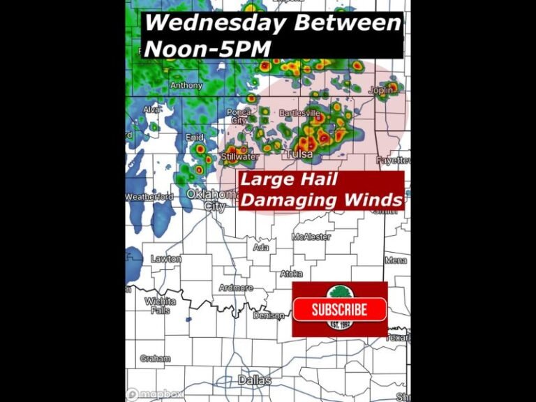
Strong Cold Front Sweeps Across Texas, Oklahoma, and Surrounding States Bringing 40 MPH Wind Gusts and Sharp Temperature Drop
DALLAS, TEXAS — A strong cold front is blasting through the southern Plains this evening, bringing gusty northwest winds and a sharp drop in temperatures across Texas, Oklahoma, Arkansas, Louisiana, and parts of New Mexico. Forecasters warn that wind gusts could reach 25–40 mph, creating hazardous travel conditions and noticeably colder air through Wednesday morning.
Cold Air Surges South With Powerful Winds
Meteorologists say the front is moving quickly, with temperatures behind it falling 15–25 degrees within just a few hours. The National Weather Service reports that northwest winds are sweeping across much of the region, producing widespread gusts strong enough to make driving difficult on east-west highways, especially for high-profile vehicles.
By late tonight, winds across north and central Texas are expected to remain sustained between 20–30 mph, with higher gusts approaching 40 mph in open areas. Similar conditions are being observed across western Oklahoma and eastern New Mexico, where the cold front first entered the region earlier in the afternoon.
Temperature Drop Brings Early Taste of Winter
Behind the front, air temperatures are plunging rapidly. Forecasts show readings in the mid-30s to low 40s across northern Texas and Oklahoma overnight, with colder wind chills making it feel even more brisk. In Arkansas and northern Louisiana, temperatures will fall into the 40s and 50s by early Wednesday morning.
Meteorologists describe this as one of the more powerful cold air intrusions so far this season, signaling a pattern shift toward early winter conditions. “This is a fast-moving system, but it’s packing strong winds and a serious punch of cold air,” a forecaster said Tuesday evening.
Safety and Travel Precautions
Residents are urged to secure outdoor objects, such as holiday decorations, patio furniture, and garbage bins, which could be displaced by the gusty winds. Drivers are also advised to use caution on highways, particularly when traveling north-south routes that cross open terrain.
Forecasters say winds should begin to ease gradually by Wednesday afternoon, though cold temperatures will persist into the following days. The cold front’s arrival marks the beginning of a chilly stretch leading into early December, with additional systems expected to follow.
For ongoing weather updates and safety alerts, visit SaludaStandard-Sentinel.com.