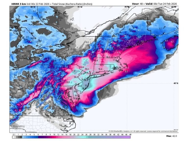
Winter Storm System Expected to Bring Snow and Ice Across Oklahoma, Kansas, Missouri, and Illinois Next Week
TULSA, OKLAHOMA — Forecasters are monitoring a developing winter storm system that could bring a mix of snow, sleet, and freezing rain across parts of Oklahoma, Kansas, Missouri, and Illinois next week. The latest model data suggests a growing likelihood of widespread winter precipitation, with significant impacts possible across the southern Plains and Midwest.
Forecast Models Show Expanding Winter Threat Zone
Meteorologists say the storm system is expected to form over the southern Plains early next week, fueled by cold Arctic air pushing southward and moisture streaming north from the Gulf of Mexico. This combination could create hazardous travel conditions across multiple states.
Forecast charts show a large band of snow and ice potential stretching from northern Texas and Oklahoma through Kansas and Missouri, and into southern Illinois and Indiana. While exact totals are still uncertain, forecasters warn that even light accumulations of ice could lead to dangerous road conditions and possible power disruptions.
Cold Air and Moisture Will Collide
Weather experts note that this system’s track will determine the type of precipitation that falls. Areas farther north, including Kansas City and St. Louis, are likely to see mainly snow, while southern areas such as Tulsa and Springfield could experience a wintry mix of sleet and freezing rain.
“This is shaping up to be a classic early-season storm pattern for the central U.S.,” one meteorologist said. “The ingredients are there for snow to the north and a messy ice mix further south.”
Residents Urged to Prepare for Travel Disruptions
With the system still several days out, the National Weather Service and local offices are urging residents to monitor forecasts closely and avoid unnecessary travel during periods of active snowfall or freezing rain.
If the storm develops as projected, it could cause road closures, flight delays, and scattered power outages across the region by early next week. Officials are also encouraging drivers to stock emergency kits and check vehicle batteries and tires ahead of the cold blast.
Forecasters say additional model runs over the coming days will clarify whether the system intensifies into a major snow-and-ice event or tracks slightly farther north, shifting impacts accordingly.
For verified weather updates and emergency preparedness tips, visit SaludaStandard-Sentinel.com.