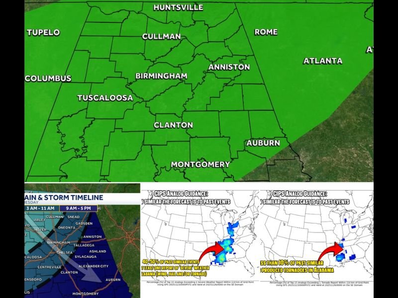
Storm System to Bring Isolated Severe Weather and Rainfall Across Alabama, Tennessee, and Mississippi on Tuesday
BIRMINGHAM, Ala. — The Storm Prediction Center (SPC) has issued a Marginal Risk (Level 1 of 5) for severe weather across Alabama, southern Tennessee, northern Georgia, and much of Mississippi for Tuesday, November 25, as a storm system slowly moves through the Southeast.
Forecasters say residents can expect scattered thunderstorms, strong wind gusts, and brief tornado potential, though widespread severe weather is not anticipated. The system’s slow movement could also bring beneficial rainfall to areas of north and central Alabama.
Marginal Risk Means Isolated Severe Storms Possible
The SPC’s Marginal Risk highlights isolated severe storms that may be limited in coverage and duration but still capable of producing brief damaging winds or an isolated tornado.
Meteorologists emphasized that the overall setup is not conducive to a major outbreak, but residents should still remain weather-aware as the system moves through.
“Tuesday’s threat is enough to be aware of — and think about your tornado plan — but it’s not a guarantee you’ll have to use it,” forecasters noted.
Timing: Monday Night Through Tuesday Evening
The storm line will develop late Monday night, moving into northwest Alabama and northeast Mississippi early Tuesday morning.
By mid-morning to afternoon, storms will spread across central Alabama and into Georgia, gradually weakening by evening.
Because the system is slow-moving and relatively disorganized, meteorologists expect the majority of activity to come in clusters of rain and embedded thunderstorms, limiting the risk for severe characteristics.
“It’s the isolated storms that break away from the clusters that we’ll need to watch most closely,” forecasters added.
Tornado Threat Low, But Not Zero
While tornado potential remains low, a brief spin-up tornado can’t be ruled out. Residents in Birmingham, Tuscaloosa, Huntsville, and Montgomery are advised to review tornado safety plans and ensure weather alerts are active, especially overnight.
Parents are also encouraged to discuss safety steps with children home for Thanksgiving break, including how to receive warnings and where to shelter.
Rainfall Brings a Silver Lining
Forecasters say most of north and central Alabama can expect between 1 and 2 inches of rainfall, which will help alleviate ongoing dry conditions.
The slow-moving front may also bring steady showers throughout the day, helping to replenish soil moisture across the region.
“The best news is that we’re going to get some good rain out of this system,” meteorologists said. “It’s a much-needed boost heading into Thanksgiving week.”
How to Stay Safe During Tuesday’s Storms
- Keep multiple ways to receive warnings, including NOAA radios and mobile alerts.
- Avoid travel during heavy rain or severe weather periods.
- Stay indoors and away from windows during thunderstorms.
- Move to a safe space — preferably an interior room on the lowest floor — if a warning is issued.
The storm system is expected to move east of Alabama by late Tuesday night, clearing the way for calmer weather and cooler temperatures on Wednesday.