Low-End Tornado Risk Issued for West Texas as Storm System Moves In
MIDLAND, Texas — Meteorologists are warning residents across West Texas to stay alert this afternoon and evening as a low-end tornado threat develops ahead of an approaching storm system. While the setup isn’t ideal for a widespread outbreak, a few quick, weak tornado spin-ups can’t be ruled out.
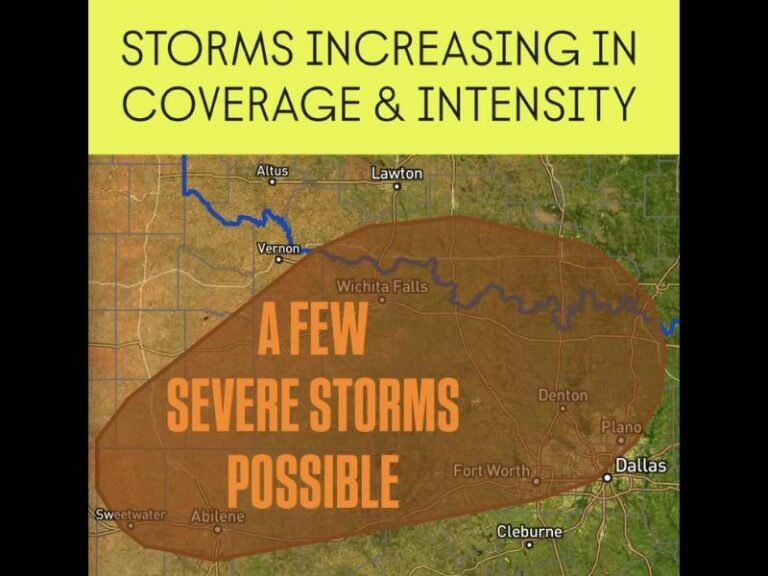
According to the latest forecast map, the tornado risk area extends from Odessa and Midland to Big Spring, Sweetwater, and Abilene, with “a couple of tornadoes possible” as conditions evolve through the evening hours.
Meteorologists Warn of “Tricky Setup”
Forecasters describe today’s conditions as a “high shear, low storm energy” environment — meaning there’s plenty of atmospheric rotation but limited instability to support large-scale storm development.
This type of setup can lead to short-lived, unpredictable tornadoes, often forming quickly and dissipating just as fast.
“Sometimes these setups can overperform, and sometimes nothing at all happens,” forecasters explained. “It’s best to stay weather-aware and have a reliable way to receive warnings.”
Timing and Affected Areas
- When: Friday afternoon through late evening, November 23
- Where: West Texas, primarily from Odessa and Midland eastward toward Sweetwater and Abilene
- Threats: Isolated tornadoes, strong wind gusts, and localized hail
While widespread severe weather is not expected, the Storm Prediction Center (SPC) has urged residents to monitor updates as the system progresses. Even low-end risk days can produce dangerous conditions, especially if storms intensify rapidly.
Safety Precautions for Residents
Emergency officials remind West Texans to stay ready in case warnings are issued:
- Keep a NOAA weather radio or mobile alert system turned on.
- Avoid outdoor activities during evening hours.
- Identify your safest indoor shelter, such as a small, windowless room on the lowest floor.
- Avoid driving during thunderstorms or crossing flooded roadways.
Outlook Heading Into the Weekend
As this system moves eastward overnight, it’s expected to bring additional rain and scattered storms into central and eastern Texas, but the tornado potential should gradually diminish by Saturday.
Residents are encouraged to stay informed and prepared. Even minor risk days can turn volatile under the right conditions — especially in regions with strong wind shear and developing cold fronts.
Stay tuned for updates from local weather authorities and national meteorological services.