3 Inches of Hail Blankets Sullivan, Indiana, Creating Rare “Hail Fog” and Snow-Like Scenes After Powerful Storm
INDIANA — A powerful storm dumped an estimated three inches of hail near Sullivan, Indiana, transforming roads and fields into snow-like landscapes and producing a rare phenomenon known as “hail fog.”
Residents described the scene as winter returning overnight — but instead of snow, the ground was covered in frozen pellets of hail.
Three Inches of Hail Reported
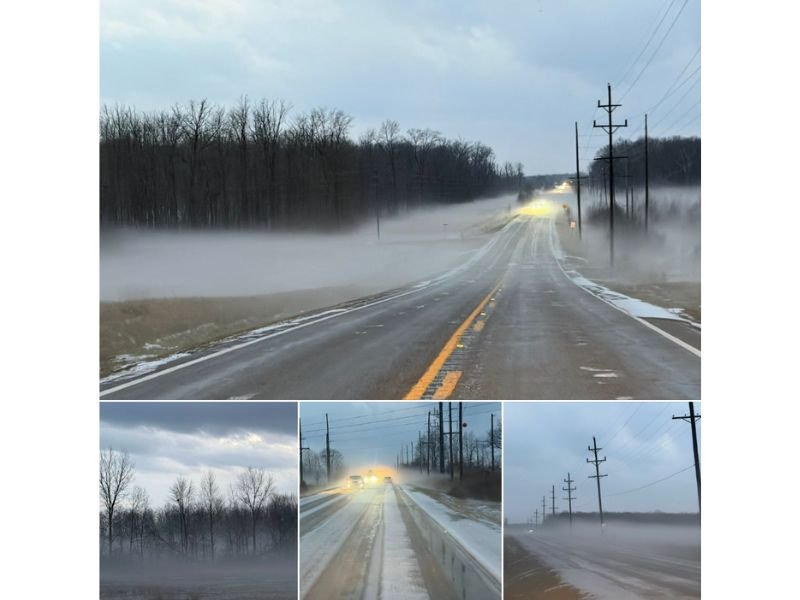
Storm reports indicate hail accumulated to roughly three inches deep in parts of Sullivan County. The frozen layer blanketed roadways, shoulders, and open fields, creating slippery driving conditions and a dramatic visual transformation.
Photos from the area show highways coated in white, with vehicles driving cautiously through what appears to be a light snow cover. However, the accumulation is entirely hail — formed inside intense thunderstorm updrafts, not from typical winter precipitation.
Unlike snow, hail develops when strong storm updrafts carry water droplets high into freezing levels of the atmosphere. The droplets freeze, grow in layers, and eventually fall to the ground when they become too heavy.
Rare “Hail Fog” Develops
In addition to the deep hail accumulation, a visible mist or fog formed close to the ground — commonly referred to as “hail fog.”
Hail fog occurs when a large amount of hail falls onto relatively warmer ground. As the hail rapidly cools the surface and melts slightly, moisture evaporates and condenses in the cold air just above the ground, creating a fog-like appearance.
Images from Sullivan show a low-lying mist drifting across roadways and open fields, reducing visibility and adding to already hazardous travel conditions.
Dangerous Driving Conditions
Roads coated in hail can be just as slick — or even slicker — than snow. The icy pellets can:
- Reduce tire traction
- Create slushy, uneven surfaces
- Cause hydroplaning when melting begins
- Obscure lane markings
Drivers in the area were urged to slow down and use caution as emergency crews assessed road conditions. The combination of hail buildup and hail fog created an especially dangerous environment for motorists during and after the storm.
Not Snow, But Just as Impactful
Though it resembled a winter storm scene, this event was entirely thunderstorm-driven. Hail accumulations of this depth are uncommon and typically occur during intense convective storms with strong updrafts capable of repeatedly lifting hailstones through freezing layers.
Such storms can also bring:
- Frequent lightning
- Strong wind gusts
- Heavy rainfall
- Potential localized damage
Storm Season Already Active
This event highlights how quickly severe weather can create unexpected hazards, even outside of traditional winter months. What looked like a snowfall in Sullivan was actually the aftermath of a powerful thunderstorm capable of producing significant hail accumulation.
Residents are encouraged to monitor forecasts during active storm periods, as hail-producing storms can develop rapidly and create hazardous conditions in a short amount of time. Stay with SaludaStandard-Sentinel.com for continued coverage of significant weather events impacting communities across the United States.